


We're continuing to track a strong spring storm system that will bring impacts to Ohio throughout the weekend. It will bring rain, storms, wind and eventually much cooler temperatures after a very warm week for most of the state.
Some thunderstorms are moving across parts of the state this morning. This activity could include strong winds, large hail and an isolated tornado.
Additional showers, downpours and thunderstorms will be possible throughout the day. The highest coverage of rain will probably be later Saturday through Saturday night and early Sunday.
This is when the rainfall will likely be the most widespread overall for the state. This is also the window in which some flooding could occur. This will be especially true if heavier rainfall moves over the same areas over and over again.
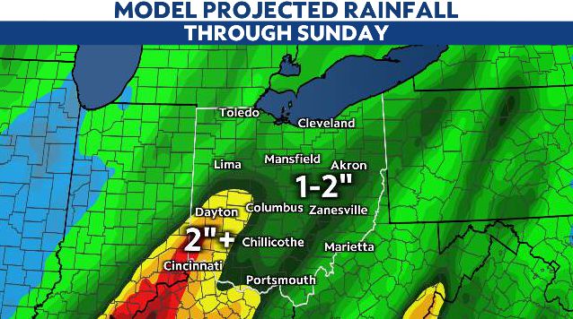
Generally speaking, the state will see 1-2" of rain with this system; totals most locations should be able to handle. Some places may not quite reach one inch of rain while other places will exceed two inches of rain.
The chance of rain will decrease through the day Sunday as colder air pours in behind the cold front. This colder air mass will be around for St. Patrick's Day on Monday before we warm back into the 60s and 70s Tuesday and Wednesday.