
NEW YORK CITY — Hurricane Isaias made landfall in North Carolina late Monday evening and is expected to impact most of the eastern seaboard over the next couple of days, including New York City on Tuesday.
The storm came ashore with maximum sustained winds of 85 mph near Ocean Isle Beach, North Carolina, about 20 miles southwest of Wilmington.
Isaias was sustaining tropical-storm winds for most of Monday, but it restrengthened into a hurricane before making landfall late Monday evening.
The storm is expected to arrive in New York City on Tuesday. (A storm that passed through parts of the five boroughs on Monday was unrelated to Isaias.)
NY1 forecasts indicate that the greatest risk for flooding on the city's southern shores, like the Rockaways, Coney Island and Lower Manhattan, will occur between 7 p.m. and midnight. The water is expected to rise rapidly between 4 p.m. and 8 p.m. on southern shores. Flooding is not expected during both high tide (10 a.m.) and low tide (2 p.m.) on the south shore.
Some flooding may occur on the streets of Staten Island and in the Rockaways in the afternoon and evening on Tuesday. Minor flooding is also possible at the Battery, but widespread water is not expected on the streets of downtown Manhattan at this time.
Storm surges are not expected to approach the levels they approached during Sandy, according to the National Weather Service. They are projected to reach 7.8 feet at their peak at the Battery on Tuesday. They reached 13.8 feet during Sandy.
On the north shore, the NY1 forecast indicates that the greatest risk for flooding is between 11 p.m. Tuesday and 1 a.m. Wednesday, also after the projected time for both high tide (2 p.m.) and low tide (8 p.m.).
Wind could also be an issue with the storm. Gusts of wind could blow as high as 60 mph and could cause issues with downed trees in Brooklyn and Queens, and on Staten Island.
Isaias is expected to weaken into a tropical storm again before it makes landfall Tuesday. Tropical storm and flash flood warnings are in effect for all of New York City Tuesday, and the worst of the storm is expected between 3 p.m. and midnight, forecasts show.
The city could see between two and four inches of rain, but up to six inches is possible in isolated spots, according to the forecast.
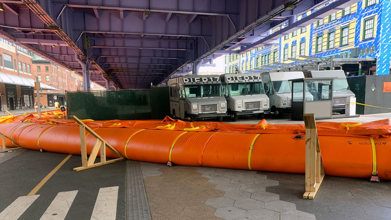
As Isaias barreled toward the outer boroughs Monday, the city rushed to protect the lower Manhattan shoreline, which officials said could be “particularly vulnerable" to sea surge.
“By the time we’re done tonight we should have one seamless barrier to protect from the 1 to 2 feet of inundation or storm surge that we think we’re going to see,” said Emergency Management Commissioner Deanne Criswell.
New York City’s Emergency Management team began this weekend shoring up the downtown Manhattan coastline, creating a temporary barrier of tiger dams and Hesco barriers from Catherine Slip by the Brooklyn Bridge down to Wall Street, de Blasio said at a press conference at the South Street Seaport Monday afternoon. Preexisting barriers and sand bags will also help mitigate the impact.
The mayor was asked why the city is not adding those protections in other flood-prone areas in Brooklyn, Staten Island and Queens. He says the city is focusing efforts on Lower Manhattan because models suggest it will be hit the hardest.
“Every storm is different, and each storm is based on, they do the work based on the projections. They have an effect. I have many times experienced storms that had very different effects in different parts of the city,” de Blasio said.
He also added that as a result of Hurricane Sandy, many other coastal protections are already in place.
Emergency management crews have also cleared flood basins across the city and the agency sent respondants into the five boroughs to response to any floods that occur, Criswell said.
All city beaches will be closed on Tuesday, and lifeguards will not be on duty, but surfing will be allowed in some areas, the city announced Monday afternoon.
SeaStreak ferry service will also be suspended Tuesday, and will resume on Wednesday.
In the Rockaways on Monday, surfers and swimmers said the waves were already tough and that there was a lot of seaweed in the ocean, two signs that a storm is coming.
Residents and business owners in the Rockaways were taking precautions on Monday, making sure devices were charged preparing for possible power outages, and bringing valuables to higher levels.
"I mean, I'm always concerned. I mean, I'm just like a worried person. But I'm ready," said one person in the Rockaways. "I mean, we have flashlights, batteries, so we'll see."
"It's kind of unthinkable that they're not doing more here to prepare," said another.
"You get some extra water, and your milk and your bread and stuff like that," said a third. "But you know what, I do definitely got to look out for my mother because she definitely got a big flood, over four feet from Sandy, so I definitely got to keep a look out on that."
The commissioner urged New Yorkers to secure loose objects outside and to avoid any potential flood areas.
Bobby Cuza, Kathleen Culliton, John Davitt, Alyssa Paolicelli and Shannan Ferry contributed to this report.
------
Did you know you can now watch, read and stay informed with NY1 wherever and whenever you want? Get the new Spectrum News app here.