
Here's the latest on Tropical Storm Isaias, which brought heavy rain and winds to the five boroughs Tuesday.
[11:45 p.m. Tuesday]
Isaias has moved into Canada and is no longer a tropical system, but New York City, and areas along the Eastern seaboard, will be dealing with its fallout for days.
The storm dropped less rain on the region than was forecasted - the city registered less than an inch of rain from a storm that was forecasted to provide two to four inches of rain - and coastal regions largely avoided the storm surges that made Sandy so devastating.
However, wind was a problem. Gusts got as high as 78 mph at the Battery, and those strong winds uprooted many trees and downed power lines in areas where those were above ground. One person was killed by a fallen tree in Briarwood, Queens.
More than 100,000 Con Edison customers remain without power across the five boroughs as of 11:30 p.m. Tuesday. (A customer does not necessarily equal a household; in some cases, that number can include entire apartment buildings.) Con Edison had estimated on its website that power would be back in several boroughs by later tonight for most of the afternoon and evening, but they have since removed all references to time frames and have simply listed "Evaluating Condition" under "Estimated Time of Restoration."
[11:15 p.m. Tuesday]
By 11:15 p.m. Tuesday, the number of Con Edison customers without power in Brooklyn was about 10,500, an improvement from the more than 22,000 customers that lost power earlier in the day.
Among those waiting to have power restored as of 10 p.m. were residents at a Red Hook NYCHA building, who were alarmed to know it could be days before electricity is returned.
A spokesperson for NYCHA explained that the storm damaged two of the three main power lines serving the building. The agency did not have an estimate on how long repairs would take and when power would restore.
Anyone can report an outage or request information by calling 1-800-75-CONED.
[10:30 p.m. Tuesday]
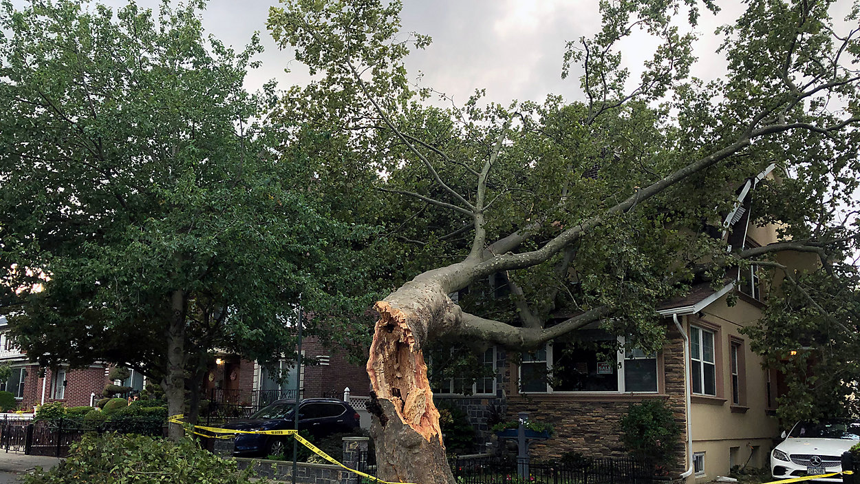
One of the many areas where trees toppled Tuesday was the area across Bay Ridge and Dyker Heights.
At the corner of 80th Street and 12th Avenue in Dyker Heights, Reyes Martinez was startled by a sound Tuesday afternoon while working in his home office.
A tree fell right into his home during Tropical Storm Isaias, smashing windows and damaging property. A neighbor's car was also damaged.
Martinez says he’s grateful his family is safe, though he’s unsure how much repair work his home will need.
Jeff Brady faced a similar issue in Bay Ridge. A tree toppled onto his home on 97th Street between Marine Avenue and Shore Road.
Brady says his wife was home and called him when she heard a loud noise. Thankfully, nobody was hurt.
Brady also says he’s grateful everyone is OK. He jokingly placed a "For Sale" sign on his window saying “tree included.”
Trees across Dyker Heights and Bay Ridge had been taped off by Tuesday evening, but are yet to be removed.
[9:20 p.m. Tuesday]
Looking ahead to the weather forecast for the rest of the week, with Isaias out of the picture and with many people potentially dealing with power outages beyond Tuesday: highs will be in the 80s, lows will be in the low 70s, and there will be no rain until passing showers pass through the area on Friday.
[8:45 p.m. Tuesday]
Mayor Bill de Blasio traveled to Astoria Tuesday evening to assess storm damage there.
He spoke with a homeowner whose house was damaged by a fallen tree, as well as a couple who had a tree fall on their car.
[8 p.m. Tuesday]
The National Weather Service has canceled the tropical storm warning for the five boroughs.
The worst of the winds were expected to ease by 8 p.m. as well.
[7:50 p.m. Tuesday]
Con Edison now says Isaias has caused the second-largest of any weather event in their history, behind only Sandy.
The number of outages has dipped slightly in the past hour. It currently sits at 128,374 customers.
Queens and Staten Island continue to have the highest number of outages. Con Ed says that's because there are more trees there to fall on power lines.
The biggest difference between outages during Isaias and Sandy has been in Manhattan, which has consistently had the fewest outages throughout the day. Manhattan usually avoids widespread outages because the power lines are underground, but there were significant outages in Manhattan during Sandy after rising storm surges caused an explosion at an East River power plant.
(A "customer" outage does not necessarily reflect one resident or household. For example, in some instances, a "customer" outage could reflect an entire residential building.)
[6:30 p.m. Tuesday]
Con Edison's reported customer outages are now above 130,000 for the five boroughs.
Queens still leads the way, with a little more than 49,000 outages.
Staten Island's numbers have actually dropped a little. They are now seeing a little more than 36,600 outages, about 1,200 less than at 5 p.m.
Brooklyn is seeing more than 22,800 outages, and the Bronx is seeing more than 21,900.
Manhattan is seeing only three reported customer outages total at this point, a far cry from the widespread outages during Sandy that were triggered when an East River plant was hit with a huge storm surge, causing an explosion.
[5:20 p.m. Tuesday]
A tropical storm warning remains in effect for the five boroughs, but there are signs the storm's impact is starting to wane.
Coastal flooding is now unlikely. Winds are shifting rapidly, and NOAA tide gauges show water levels dropping.
Strong winds are still lingering in the city, but they are expected to ease by 8 p.m.
Rain totals also turned out to be much less than what was in the forecast. The city registered less than 1 inch of rain across the five boroughs, well short of the 2 to 4 inches that were originally forecasted.
[5 p.m. Tuesday]
Con Edison's latest outages update is in, and the number has gone up. More than 128,000 customers are now without power across the five boroughs.
The biggest jump seems to have taken place on Staten Island. More than 37,800 customers are now without power there. That number is up by about 10,000 from an hour ago.
Queens still has the most outages, with more than 46,500. There are more than 21,700 outages in the Bronx and more than 22,600 outages in Brooklyn.
In addition, closings and restrictions on some city bridges have been lifted.
The Verrazzano-Narrows Bridge has reopened with delays. All lanes are open except the upper level eastbound (to Brooklyn).
The truck ban has been lifted on the Throgs Neck and Bronx-Whitestone Bridges, but may be reinstated at any time for sustained high winds.
[4:30 p.m. Tuesday]
In addition to the tree that fell and caused a person's death in Queens, Isaias has led to downed trees all across the five boroughs. Mayor de Blasio puts the number at roughly 2,000, though he cautions the count is preliminary.
Here is a sample of some of the damage that's been seen by our reporters and producers in the field:
[3:45 p.m. Tuesday]
Con Edison says approximately 110,000 customers are without power in New York City as Isaias' impacts continue to be felt across the five boroughs.
The utility says only Hurricane Sandy and Tropical Storm Irene have resulted in more outages than Isaias.
As of 3:45 p.m., Queens had the most reported customer outages, with more than 41,000. There were also more than 28,000 on Staten Island, more than 20,000 in the Bronx and more than 18,000 in Brooklyn.
A "customer" outage does not necessarily reflect one resident or household. For example, in some instances, a "customer" outage could reflect an entire residential building.
The utility says workers are now heading out to assess damage after being held back during the height of the storm.
[3:35 p.m. Tuesday]
New York City is not out of the woods yet with Isaias, but certain aspects of the storm have already peaked.
The threat of flash flooding is over as the rain is mainly done, but forecasters are still on alert for coastal flooding tonight.
A tornado watch has been canceled for the five boroughs.
The worst of the winds are over as well. The highest gust recorded on Tuesday was 78 mph at the Battery - the highest wind gust since Sandy.
While the worst might be over, conditions will remain dangerous for the next few hours. New Yorkers should still avoid going outside whenever possible as the threat of downed trees remains.
[3:05 p.m. Tuesday]
Mayor Bill de Blasio confirmed that a person was killed by a fallen tree in Queens Tuesday afternoon and said another person is in critical condition after being struck by a tree in Brooklyn.
He urged New Yorkers to stay indoors until at least 5 p.m.
"This is serious stuff," de Blasio said during a phone interview with NY1's Kristen Shaughnessy. "It's still dangerous."
The mayor noted 911 calls spiked in New York City as wind speeds increased and caused power outages across the city.
"What we see now is that the storm has been more of a wind event than a flooding event," the mayor said.
Nearly 155,000 Consolidated Edison customers were without power as of 3 p.m. with 27,307 in Staten Island, 15,354 in Brooklyn, 38,298 in Queens, 21,591 in The Bronx and 17 in Manhattan.
[2:20 p.m. Tuesday]:
The MTA suspended service Tuesday afternoon on its above-ground subway, Metro-North and Long Island Railroad lines as wind gusts reached 75 mph and trees fell across the city, CEO and Chairman Pat Foye said.
"Recovery work is already underway where conditions allow that work to be done safely," Foye said.
Service was completely suspended on the 5, B, C, M, W, Z and shuttle lines and partially suspensions on the 1, 2, 3, 4, 6, 7, A, D, F, G, J, L, N and Q lines, according to the MTA website.
The Verrazzano-Narrows Bridge was closed to all traffic and trucks were banned from the Throgs Neck and Bronx-Whitestone bridges, the MTA announced.
The speed limit on the Robert F. Kennedy - or Triborough- Bridge was reduced to 10 mph, officials said.
Two trees fell on subway tracks as the MTA press briefing was taking place, said New York City Transit Interim President Sarah Feinberg.
Power outages were among the causes for service shutdowns.
Consolidated Edison reported Tuesday afternoon power outages for 28,773 customers in Queens, 27,854 in Staten Island, 16,374 in The Bronx and 19 in Manhattan.
Foye reminded New Yorkers the MTA has requested $12 billion in federal funding to ensure, among other programs, storm preparation.
[1:10 p.m. Tuesday]:
The city continues to be on tornado watch as power outages, rip tides and forecasts of 60 mph winds and potential storm surge press on.
About 11,609 are without power on Staten Island, followed by 5,591 in Brooklyn. In Queens and the Bronx, 1,312 and 597 are without power, respectively. In Manhattan, there are 17 reported outages.
Airports are reporting cancelations. At LaGuardia Airport, 78 flights have been confirmed canceled, along with 55 at John F. Kennedy International Airport. These numbers are expected to increase.
Staten Island Ferry Service will be suspended between 1:00 and 5:00 p.m.
[12:38 p.m. Tuesday]:
Heavy winds and rain from Tropical Storm Isaias are making their way through New York City as a tornado watch remains in effect until 4 p.m. across all five boroughs.
Gusts of wind could blow as high as 60 mph, and it's already causing issues with downed trees.
Power outages are also a concern as the storm whips through the area.
Consolidated Edison is reporting multiple outages in Brookyn, Queens and Staten Island.
For the latest numbers, check out the utility's outage map.
[10:16 a.m. Tuesday]:
Mayor Bill de Blasio warned New Yorkers Tuesday morning to prepare for possible tornadoes and the incoming storm.
"The threat of tornados now ... that's a lot," de Blasio said. "When you hear of a tornado warning, that is not business as usual."
New York City remains under tornado watch until 4 p.m. and coastal flood warning have been issued for parts of Brooklyn, Staten Island and Queens, according to New York City Emergency Management Department Commissioner Deanne Criswell.
New York City could see winds blow at up to 70 mph between 3 p.m. and 7 p.m. which makes tree damage possible, Criswell said.
Rip tides caused New York City to close its beaches.
NYC Ferry service will be suspended as of 11:30 a.m. and the Staten Island Ferry will operate on a modified schedule starting at 4 p.m.
Sea surge is not predicted to reach Superstorm Sandy's proportions, when the city's coast line saw waters rise 13 feet, but New York City neighborhoods near the ocean could see between 1 and 2 feet of water between 7 p.m. and 10 p.m., forecasters said.
New York City spent $20 billion in the years after Superstorm Sandy to shore up its coastline in areas hit hardest, such as Red Hook Brooklyn, the Rockaway Peninsula, and downtown Manhattan, said Jainey Bavishi, Director of the Office of Recovery and Resiliency.
"I feel good about the short term," de Blasio said. "But we have a lot to do for the long term when it comes to global warming."
Isaias Hits Land :
The storm came ashore Tuesday with maximum sustained winds of 85 mph near Ocean Isle Beach, North Carolina, about 20 miles southwest of Wilmington.
Isaias was sustaining tropical-storm winds for most of Monday, but it restrengthened into a hurricane before making landfall late Monday evening.
The storm arrived in New York City early Tuesday morning. (A storm that passed through parts of the five boroughs on Monday was unrelated to Isaias.)
NY1 forecasts indicate that the greatest risk for flooding on the city's southern shores, like the Rockaways, Coney Island and Lower Manhattan, will occur between 7 p.m. and midnight. The water is expected to rise rapidly between 4 p.m. and 8 p.m. on southern shores. Flooding is not expected during both high tide (10 a.m.) and low tide (2 p.m.) on the south shore.
Some flooding may occur on the streets of Staten Island and in the Rockaways in the afternoon and evening on Tuesday. Minor flooding is also possible at the Battery, but widespread water is not expected on the streets of downtown Manhattan at this time.
Storm surges are not expected to approach the levels they approached during Sandy, according to the National Weather Service. They are projected to reach 7.8 feet at their peak at the Battery on Tuesday. They reached 13.8 feet during Sandy.
On the north shore, the NY1 forecast indicates that the greatest risk for flooding is between 11 p.m. Tuesday and 1 a.m. Wednesday, also after the projected time for both high tide (2 p.m.) and low tide (8 p.m.).
Isaias is expected to weaken into a tropical storm again before it makes landfall Tuesday. Tropical storm and flash flood warnings are in effect for all of New York City Tuesday, and the worst of the storm is expected between 3 p.m. and midnight, forecasts show.
The city could see between two and four inches of rain, but up to six inches is possible in isolated spots, according to the forecast.
NYC Protects Manhattan Shoreline [3:10 p.m. Monday]:
As Isaias barreled toward the outer boroughs Monday, the city rushed to protect the lower Manhattan shoreline, which officials said could be “particularly vulnerable" to sea surge.
The mayor was asked why the city is not adding those protections in other flood-prone areas in Brooklyn, Staten Island and Queens. He said the city focused efforts on lower Manhattan because models suggest it will be hit the hardest. He also added that as a result of Sandy, many other coastal protections are already in place.
All city beaches will be closed on Tuesday, and lifeguards will not be on duty, but surfing will be allowed in some areas, the city announced Monday afternoon. High surf and dangerous rip currents are expected.
SeaStreak ferry service will also be suspended Tuesday, and will resume on Wednesday.