
MALIBU, Calif. — For the last two years, Woolsey fire victim Richard Gibbs has lived in a rented Malibu house. But it’s far from home.
“I mean, I feel at home in Malibu, but this is not our home," Gibbs said. "Our home burned down, this is our house.”
What You Need To Know
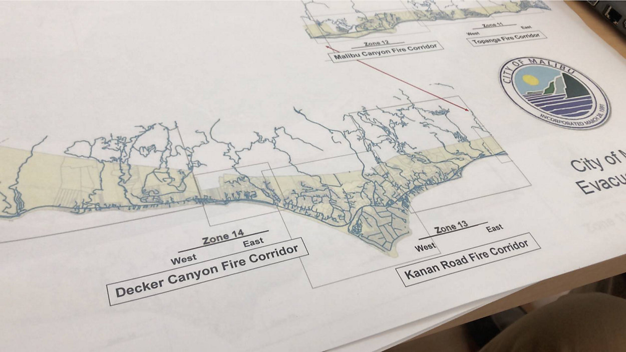
- Malibu has been divided into four fire evacuation zones along four fire corridors (Malibu Canyon, Topanga Canyon, Kanan Road, and Decker Canyon)
- Topanga’s evacuation zones are 1-9, while Malibu’s evacuation zones will be 11-14
- Residents can find out which evacuation zone they are in by visiting the city of Malibu's website
- There will be a virtual meeting on Malibu's evacuation zones on September 23
Gibbs still remembers that day in November 2018. His friends from New Zealand, who were staying at his house evacuated early, while he stayed behind to pack and fire-proof the home.
“Somewhere around midday, around noon or so, the kiwis came back, my studio manager and his family, and I said, 'What are you doing? Why did you come back?'" Gibbs said. "And he said, 'Well, we’re almost out of gas. We sat on PCH for 2 hours and a half and only managed to travel about two miles.'"
They tried again and evacuated successfully. Their home burned along with about 400 others — the only thing left standing was his recording studio. He said no one came to put out the fire in his neighborhood. “We spent a lot of time just picking up the pieces after the fire."
Gibbs recently tuned in to the city of Malibu’s virtual meeting where the new evacuation zones were addressed. The person leading the discussion was Jerry Vandermeulen, a retired battalion chief from the Ventura County Fire Department and the city’s first fire safety liaison.
Vandermeulen helped draw the zones in collaboration with the L.A. County Fire and Sheriff’s departments.
“The four primary routes of fire travel for fires that come into Malibu are Topanga Canyon, Malibu Canyon, Kanan Road and Decker Canyon," he said. "So the decision was made to set up the evacuation zones along those corridors."
Topanga’s evacuation zones are 1-9, and Malibu’s zones will be 11-14. Residents can find out what zone they’re in through the city’s website.
“Our residents will be able to go to the website, type in their address and it will bring up a map showing their location in a zone that they reside in,” Vandermeulen said.
City officials hope the new zones will allow for a more phased evacuation of the city, preventing a repeat of the Woolsey fire traffic jam.
Gibbs also wanted to have a lane of westbound PCH turned into an Eastbound lane heading towards Santa Monica during major fires and evacuations, a sentiment mirrored by many residents. After discussing it with their law enforcement partners, city officials were told that, because law enforcement has to inform and enforce the evacuations, they simply don't have the number of personnel needed to make those road changes and execute neighborhood evacuations at the same time.
As to the evacuation zones, Gibbs said this is a good, first step. After all, it’s not just confusion and traffic jams that kept some people from evacuating.
"They’re not addressing how are they going to inspire people to leave," he said. "How are you going to get people to evacuate? People are going to stay because they don’t believe their homes are going to be saved.”
Therefore, despite the new evacuation zones, Gibbs fears even more people will stay behind next time, and that many more could get hurt.
Residents will receive mailers in the coming weeks informing them which zone they reside in. The mailers also will have details about another virtual meeting on the topic the city is hosting on September 23.