
ORLANDO, Florida — Hurricane Michael is now a dangerous category 4 hurricane and is projected to maintain that strength at landfall.
- Hurricane Michael now Category 4
- Tropical Storm Nadine has formed
- Some are riding out storm where they are despite evacuation order
- RELATED:
- JUMP TO: Latest Advisory Numbers on Michael | Leslie | Nadine ▼
- LIVE UPDATES: Hurricane Michael Threatens Florida
- Marion County Giving Out Sandbags
- Airbnb Opens Homes for Hurricane Michael Evacuees
- FEMA urges evacuations
- Latest from Spectrum News reporters in the Florida Panhandle
- TRACKING THE TROPICS: Watches, warnings, forecasts, spaghetti models
Maximum sustained winds are at 130 mph as it moves north over the Gulf of Mexico at 12 mph. A northeastward motion is expected later today, which will push Michael across the southeastern United States.
According to records going back to 1851, no storm Category 4 or greater has ever made landfall in this part of the state.
The latest forecast track shows landfall somewhere between Panama City and Mexico Beach this afternoon.
While the worst of the impacts will stay north and west of central Florida, tropical moisture continues streaming into the area with occasional strong squalls of rain and gusty winds. We do have a chance for severe weather with any squall that moves through and an isolated tornado cannot be ruled out.
The center is located 180 miles south-southwest of Panama City and 170 miles southwest of Apalachicola. Hurricane force winds extend outward to 45 miles and tropical storm force winds extend out 175 miles. The minimum central pressure is 945 mb.

The following advisories are in effect:
Storm surge warning:
- Okaloosa/Walton County Line, Florida to Anclote River, Florida
Storm surge watch:
- Anclote River, Florida to Anna Maria Island, including Tampa Bay
- Alabama/Florida border to Okaloosa/Walton County Line, Florida
Hurricane warning:
- Alabama/Florida border to Suwannee River, Florida
Tropical storm warning:
- Alabama/Florida border to the Mississippi/Alabama border
- Suwanee River, Florida to Chassahowitzka
- Fernandina Beach, Florida to South Santee River, South Carolina
Tropical storm watch:
- Chassahowitzka to Anna Maria Island, including Tampa Bay
- Mississippi/Alabama border to the mouth of the Pearl River
- South Santee River, South Carolina to Duck, North Carolina
- Pamlico and Albemarle Sounds
Rainfall of 4 to 8 inches is possible in the path of Michael, the Florida Panhandle, and southern Georgia, southeast Alabama and portions of southwest of central Georgia. Localized amounts to 12 inches are possible which could lead to life-threatening flash flooding.
In Central Florida, the onshore winds will generate off and on gusty squalls throughout the day. Higher rain chances will continue through Thursday before drier air slides down the peninsula behind Michael.
In the Panhandle
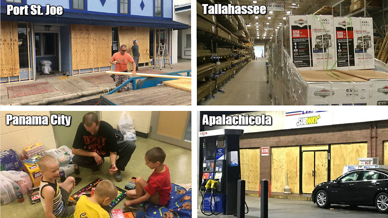
In one of two Panama City shelters, John Newman and his family are getting settled and trying to find distractions for their three young boys.
"We packed a lot of food, hopefully enough for a few days, and clothes, blankets, a game to try to keep the kids entertained," Newman said.
"We live right by the water. Hopefully when it's all done, we still have a home to come back to," he said.
Panama City Beach resident Dennis Bush said he's staying home for now, despite being in a mandatory evacuation zone.
"We want to get all boarded up and prepared and then we're going to see if it strengthens and if it strengthens, we're going to probably head on out of town," Bush said. "My biggest concern is flooding."
— Melissa Eichman
Having been hit just two years ago by Hurricane Hermine, Florida's capital city is all too familiar with the power of a major hurricane.
Supplies were going fast at Tallahassee-area stores. Grocery store shelves were quickly becoming bare Tuesday. Most popular: propane, lanterns and water. There were long lines at gas stations, where many stations sold out, and resupplies were not expected until after the storm passed.
Local officials were recommending that people voluntarily evacuate Tallahassee as power outages are likely, possibly for a period of weeks. Though many people have evacuated, some remained behind. Tallahassee is particularly vulnerable to hurricanes because of its large tree canopy. Roots become saturated, then trees can come down, knocking out power lines and damaging roofs. After Hermine, power was out for days. This time, 20 out-of-town power crews are on standby to help.
— Troy Kinsey
In Panama City, one man who lives on his boat in the marina spent the morning trying to lift the boat as high as he can, but he expects Hurricane Michael to destroy the boat – and his home.
His mother lives at a housing tower across the street. She looked on after she – along with dozens of other people – were forced to leave that building early Tuesday morning.
The two say they’ll be heading to Tallahassee to ride out the storm.
"This is the first time... We've had storms come through here, but nothing major to where you have to evacuate. We rode it out really good, but this one, I’m not so sure about it," Lily Wilder said.
Despite mandatory evacuations, many people we talked to said they're riding out the storm in their homes.
The owner of a clock store said he has a safe home to stay in and wants stay in town to check on his store. He recruited several friends and family members to help him board up windows.
"It says it's coming straight to us, so we want to be as prepared as we can," business owner Bill Miller said.
— Jeff Allen
On Watson Bayou in Panama City, friends are helping friends.
C.J. Johnson and his friends spent Tuesday securing boats before Hurricane Michael hits. But he said the biggest problem is that everything in the city is "low."
“It’s just low, everything is low in Panama City ... once we get a storm surge coming in, we have no place to go,” Johnson said.
The storm surge is a problem for everyone along the water.
"We are pretty worried about it — it is coming up," said Lee Brown, who lives in Lynn Haven. "If it gets probably to that six or eight foot range, that is where we are really going to have to make a decision.”
The decision to stay or go is tough for everyone.
“We can just pray that it will be another Opal and it will downgrade," Brown said.
As for gas, a few stations still had some left Tuesday, but many stations are out. One station said they felt it was important to stay open until the last drop was gone, because so many people needed it.
— Erin Murray
FEMA Urges Evacuations
During a news conference Tuesday morning, FEMA warned those in Hurricane Michael's path to steer clear of it.
"The time to evacuate and heed the local warnings is now," said Jeffrey Byard, the associate administrator for the Office of Response and Recovery at FEMA. "Hurricane Michael will be a devastating storm to a part of Florida that has not seen a storm of this magnitude in quite some time."
A weather expert for the National Oceanic and Atmospheric Administration said Michael is expected to reach "major hurricane status" in 12 to 24 hours, with a potential of climbing to a Category 3 storm.
Michael is expected to make landfall to Florida's Big Bend area sometime Wednesday, with "destructive winds" blowing at more than 100 mph.
It's expected to bring significant flooding, a 12-foot storm surge and power outages.
Duke Energy is estimating Michael could cause between 100,000 and 200,000 power outages across the state.
Health and Human Services Secretary Alex Azar in a news release has also already declared a public health emergency in Florida due to the storm and its aftermath.
— Anthony Leone
Leslie

Leslie has once again strengthened to a hurricane with winds of 75 mph. Hurricane Leslie is located about 1070 miles west-southwest of the Azores. It is moving to the south-southeast at 9 mph. Leslie will continue to move to the southeast over the next several days, taking Leslie across the central and eastern Atlantic.
Nadine

We gained our 14th named storm of the 2018 Atlantic hurricane season. Tropical storm Nadine developed over the eastern Atlantic and is moving to the west-northwest. It has winds of 45 mph. This general motion is expected over the next several days. Nadine is no threat to land.
Atlantic hurricane season runs through November 30.