
Snow will likely be falling for much of Wednesday morning across central North Carolina. The National Weather Service has already issued a Winter Weather Advisory for the region through most of Wednesday.
An Arctic cold front will approach western North Carolina late Tuesday bringing snow to the mountains Tuesday evening. Much of that snow may dry up as it moves just east of the mountains Tuesday night, but it is expected to redevelop across the Piedmont during the early morning hours Wednesday.
The snow should begin around the Triangle between 4 and 7 a.m. Wednesday. Around that same time, the precipitation will start south of Raleigh in the Sandhills near Fayetteville as a chilly rain before switching over to snow. A brief period of sleet is possible as the rain changes to snow.
Wednesday morning's band of snow across central North Carolina will be moving west to east. That should bring an end to the snow in the Triangle and Sandhills by midday or early afternoon.
Temperatures may be hovering just above freezing as the precipitation starts Wednesday morning and then fall to near 30 or the upper 20s during the day.
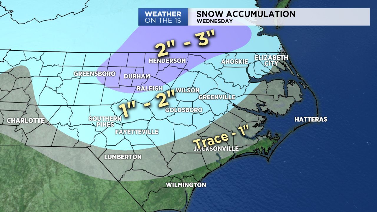
Based on the latest forecast data, it appears most of central North Carolina will see between one and three inches of snow Wednesday. The higher end of that range should come from near Raleigh to the north including Durham, Chapel Hill, Roxboro, Henderson, and Roanoke Rapids.
South and east of Raleigh one to two inches appears more likely. That would include locations near Wilson, Goldsboro, Southern Pines, and Fayetteville. South of Fayetteville near Laurinburg and Lumberton a dusting to one inch is forecast.
These forecast totals could still change by an inch or so for some spots. No matter the exact amount of snow that falls, it is important to point out that accumulating snow will likely affect road conditions across central North Carolina starting with the morning commute Wednesday and continuing through the day. Untreated roads could be especially dangerous Wednesday night into Thursday morning as temperatures drop to the teens.
Wind chills in the single digits to low teens will be possible by Thursday morning. Sunshine and highs in the low 40s should start the melting process Thursday afternoon.
Stay tuned to Weather on the 1s on Spectrum News for updates to the forecast through the day and night.
Get the latest news, sports and weather delivered straight to your inbox. Click here to sign up for email and text alerts.